1
/
of
7
PayPal, credit cards. Download editable-PDF & invoice in 1 second!
JT/T 766-2009 English PDF (JTT766-2009)
JT/T 766-2009 English PDF (JTT766-2009)
Regular price
$160.00 USD
Regular price
Sale price
$160.00 USD
Unit price
/
per
Shipping calculated at checkout.
Couldn't load pickup availability
Delivery: 3 seconds. Download true-PDF + Invoice.
Get QUOTATION in 1-minute: Click JT/T 766-2009
Historical versions: JT/T 766-2009
Preview True-PDF (Reload/Scroll if blank)
JT/T 766-2009: Technical requirements for shipborne monitoring equipment of Beidou navigation satellite system
JT/T 766-2009
JT
TRANSPORT INDUSTRY STANDARD
OF THE PEOPLE’S REPUBLIC OF CHINA
ICS 47.020.70
M 35
File No..
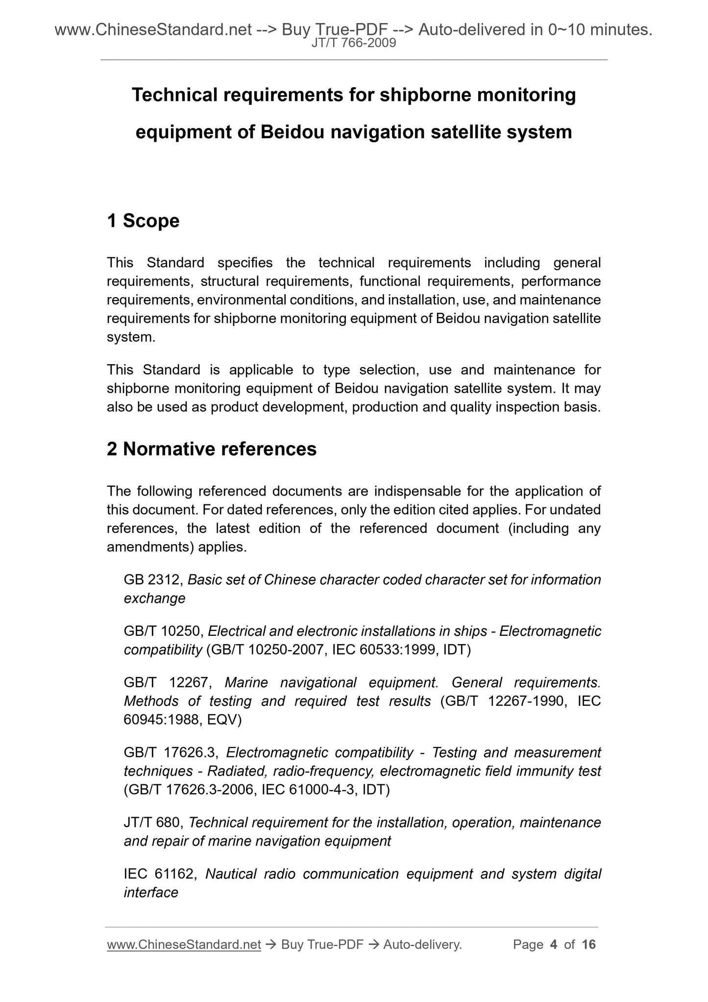
Technical requirements for shipborne monitoring
equipment of Beidou navigation satellite system
ISSUED ON. DECEMBER 23, 2009
IMPLEMENTED ON. APRIL 01, 2010
Issued by. Ministry of Transport of the People's Republic of China
Table of Contents
Foreword ... 3
1 Scope ... 4
2 Normative references ... 4
3 Terms and definitions, abbreviations ... 5
4 Technical requirements ... 6
Technical requirements for shipborne monitoring
equipment of Beidou navigation satellite system
1 Scope
This Standard specifies the technical requirements including general
requirements, structural requirements, functional requirements, performance
requirements, environmental conditions, and installation, use, and maintenance
requirements for shipborne monitoring equipment of Beidou navigation satellite
system.
This Standard is applicable to type selection, use and maintenance for
shipborne monitoring equipment of Beidou navigation satellite system. It may
also be used as product development, production and quality inspection basis.
2 Normative references
The following referenced documents are indispensable for the application of
this document. For dated references, only the edition cited applies. For undated
references, the latest edition of the referenced document (including any
amendments) applies.
GB 2312, Basic set of Chinese character coded character set for information
exchange
GB/T 10250, Electrical and electronic installations in ships - Electromagnetic
compatibility (GB/T 10250-2007, IEC 60533.1999, IDT)
GB/T 12267, Marine navigational equipment. General requirements.
Methods of testing and required test results (GB/T 12267-1990, IEC
60945.1988, EQV)
GB/T 17626.3, Electromagnetic compatibility - Testing and measurement
techniques - Radiated, radio-frequency, electromagnetic field immunity test
(GB/T 17626.3-2006, IEC 61000-4-3, IDT)
JT/T 680, Technical requirement for the installation, operation, maintenance
and repair of marine navigation equipment
IEC 61162, Nautical radio communication equipment and system digital
interface
GSM - Global System for Mobile Communications;
MTBF - Mean Time Between Failures;
MTBR - Mean Time Between Repairs;
PDOP - Positional Dilution of Precision;
PPS - Pulse Per Second;
TTFF - Time to First Fix;
UTC - Universal Time Coordinated;
VHF - Very High Frequency;
WGS-84 - World Geodetic System, 1984.
4 Technical requirements
4.1 General requirements
4.1.1 The receiver shall work reliably and be easy to operate and maintain.
4.1.2 The receiver shall have self-test function.
4.2 Structural requirements
4.2.1 Monitoring terminal antenna and host are in split design. There is cable
connection between the antenna and the host. The receiving and transmitting
antennas shall be structurally integrated.
4.2.2 The operation display screen shall be able to adjust the brightness until it
is off.
4.2.3 There shall be no obvious depressions, scratches, cracks, deformations,
etc. on the surface. The surface coating shall not blister, crack and fall off. Metal
parts shall not be corroded or mechanically damaged.
4.3 Functional requirements
4.3.1 Self-test and data retention
4.3.1.1 The monitoring terminal has power-on self-test and working condition
inspection as well as initialization and condition setting functions. In case of
failure, the fault alarm and fault type shall be given in real time, and the prompt
shall be given through visual and audio or data interface output.
The monitoring terminal shall be able to complete the following location polling
function.
a) After receiving the position polling command issued by the authorized user,
the monitoring terminal automatically calculates the shipborne position,
speed and heading according to the requirements in the command and
sends it to the authorized user through the communication module.
Automatic stop position transmission when receiving a stop position
polling command from an authorized user;
b) When the monitoring terminal successfully sends the positioning
information, it shall be able to give visual or audible prompts according to
the settings.
4.3.6.4 Without positioning prompts
When the monitoring terminal is unable to locate, it shall be able to give visual
or audible prompts according to the settings.
4.3.6.5 Positioning storage
According to the first-in-first-out principle, it has the function of dynamically
storing recent historical location information.
4.3.6.6 Waypoint function
The monitoring terminal shall be able to set and store the waypoints and
calculate the distance, bearing, waiting time and estimated arrival time of the
arriving waypoints.
4.3.7 Alarm function
The alarm functions of the monitoring terminal are as follows.
a) All monitoring terminals shall be set with distress alert button. In case of
emergency or distress, the monitoring terminal shall send a distress alert
message to the Beidou satellite navigation system and the management
terminal under the trigger of the alarm activation signal. The distress
message shall include at least the positioning time, shipborne position and
ship identification;
b) The monitoring terminal shall be able to initiate continuous transmission
of position information to the Beidou satellite navigation system and the
management terminal under the trigger of the alarm activation signal.
Sending frequency is 5s. Stop receiving positioning information after
receiving the Beidou satellite navigation system or management terminal
command.
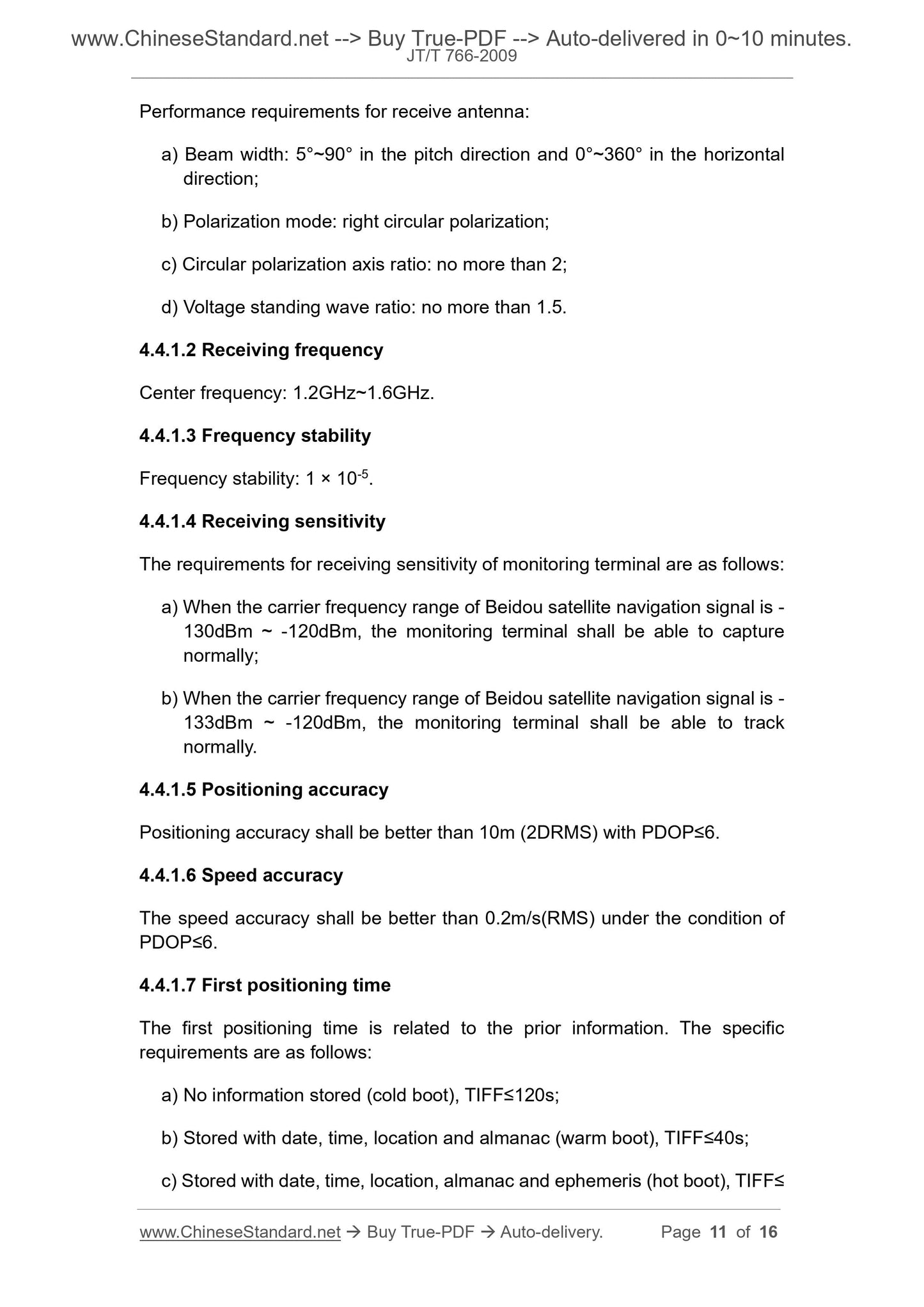
Performance requirements for receive antenna.
a) Beam width. 5°~90° in the pitch direction and 0°~360° in the horizontal
direction;
b) Polarization mode. right circular polarization;
c) Circular polarization axis ratio. no more than 2;
d) Voltage standing wave ratio. no more than 1.5.
4.4.1.2 Receiving frequency
Center frequency. 1.2GHz~1.6GHz.
4.4.1.3 Frequency stability
Frequency stability. 1 × 10⁻⁵.
4.4.1.4 Receiving sensitivity
The requirements for receiving sensitivity of monitoring terminal are as follows.
a) When the carrier frequency range of Beidou satellite navigation signal is -
130dBm ~ -120dBm, the monitoring terminal shall be able to capture
normally;
b) When the carrier frequency range of Beidou satellite navigation signal is -
133dBm ~ -120dBm, the monitoring terminal shall be able to track
normally.
4.4.1.5 Positioning accuracy
Positioning accuracy shall be better than 10m (2DRMS) with PDOP≤6.
4.4.1.6 Speed accuracy
The speed accuracy shall be better than 0.2m/s(RMS) under the condition of
PDOP≤6.
4.4.1.7 First positioning time
The first positioning time is related to the prior information. The specific
requirements are as follows.
a) No information stored (cold boot), TIFF≤120s;
b) Stored with date, time, location and almanac (warm boot), TIFF≤40s;
c) Stored with date, time, location, almanac and ephemeris (hot boot), TIFF≤
4.4.2.1.6 Receive error rate. no more than 1 × 10⁻⁵.
4.4.2.1.7 Pseudo-code tracking random error. no more than 12.5ns.
4.4.2.2 Transmitting part
4.4.2.2.1 Transmitting antenna
Performance requirements for transmitting antenna.
a) Beam width. 10°~75° in the pitch direction and 0°~360° in the horizontal
direction;
b) Polarization mode. left circula...
Share
